Pangong Lake Ladakh | Altitude, Permits, Leh to Pangong Distance & Complete Travel Guide 2026
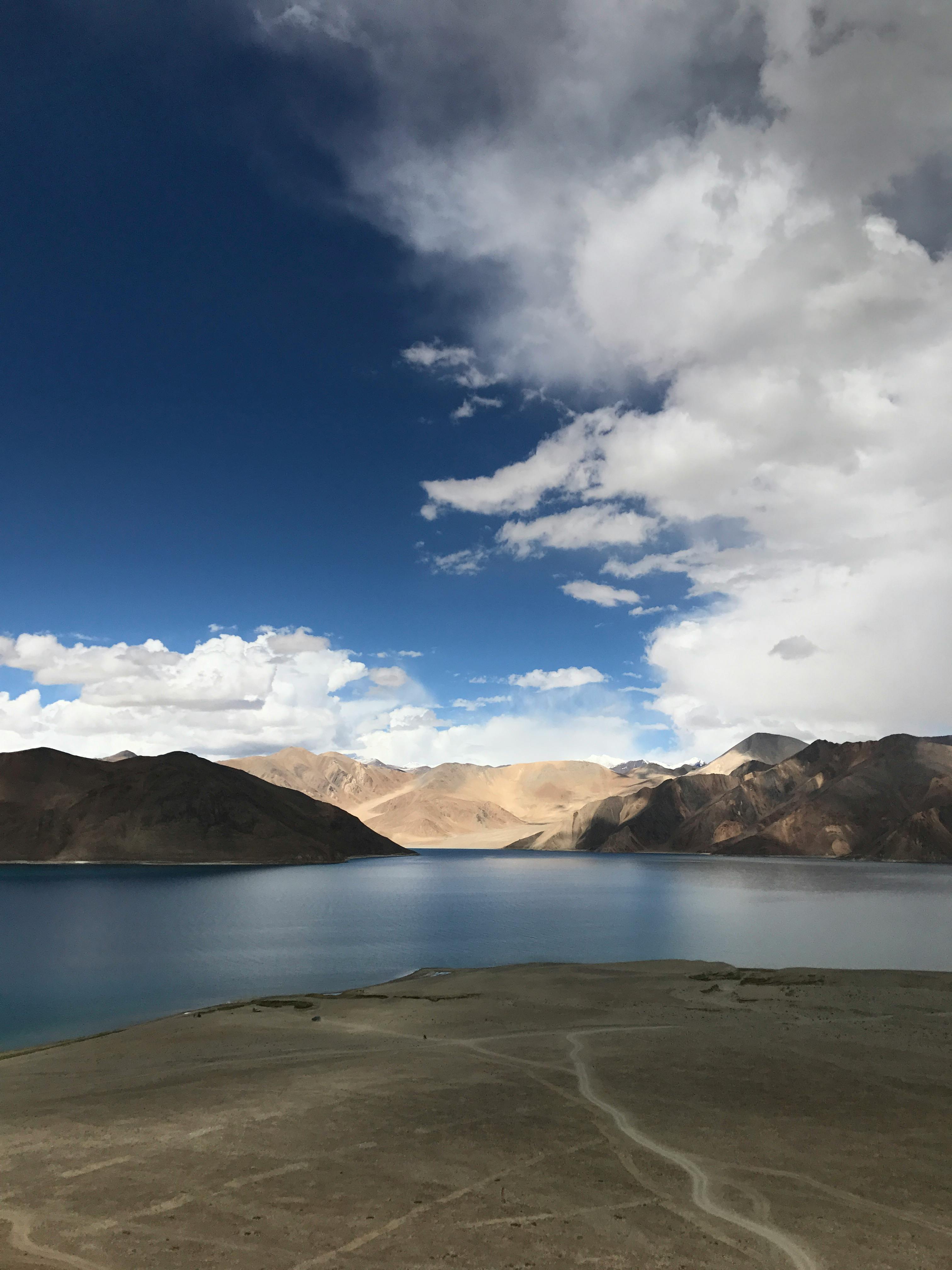
There is a moment that every traveller who has stood at the edge of Pangong Lake knows. The road ends, the dust settles, and suddenly — water. Not any water, but water in a shade of blue that seems almost digitally edited, so vivid and so utterly out of place in the barren, brown Ladakhi landscape that surrounds it. The mountains above are dry and striated. The sky is the intense, cloudless blue of the high Himalayas. And the lake itself shifts between turquoise, cobalt, emerald, and silver as the light moves across it through the day. It is one of the most genuinely extraordinary natural spectacles in India, and no amount of preparation fully prepares you for the first sight of it.
Pangong Lake — known locally as Pangong Tso — is one of the world's highest saltwater lakes, sitting at 4,350 metres (14,270 feet) above sea level in eastern Ladakh, right along the contested India–China border. At 134 km long and up to 5 km wide, it is one of the largest high-altitude lakes in Asia — yet only approximately one-third of it lies in India. The rest stretches deep into Tibet. This is your complete, honest travel guide to Pangong Lake in 2026.
Pangong Lake – Quick Reference
| Detail | Information |
|---|---|
| Also Known As | Pangong Tso |
| Location | Eastern Ladakh, India (extends into Tibet, China) |
| Altitude of Pangong Lake | 4,350 metres (14,270 feet) above sea level |
| Lake Length | 134 km |
| Lake Width (max) | ~5 km |
| Lake Depth (max estimated) | ~100+ metres |
| India's Share of the Lake | ~45 km (approx. one-third) |
| Lake Type | Saltwater / Brackish (endorheic — does not drain into any river or sea) |
| Distance from Leh | ~160 km via Chang La | ~230 km via Nubra Valley |
| Nearest Airport | Kushok Bakula Rimpochee Airport, Leh (~160 km) |
| Best Time to Visit | May to September |
| Permit Required | Yes — Inner Line Permit (ILP) for Indians; PAP for foreign nationals |
| Entry Fee | ~₹400–500 (ILP fee including environment fee) |
What Does Pangong Tso Mean?
The name Pangong Tso comes from the Tibetan language. Pangong translates roughly as "high grassland" or "extensive", and Tso simply means "lake" in Tibetan. Together, Pangong Tso means "the high grassland lake" — a name that reflects both the altitude of the terrain and the wide, flat grasslands that fringe the lake's shores. The name Pangong Lake is the anglicised version of the same name used colloquially across India.
Where is Pangong Lake Located?
Pangong Lake is located in the Leh district of Ladakh, a union territory in the northernmost part of India, at an altitude of 4,350 metres (14,270 feet) above sea level. The lake sits along the Line of Actual Control (LAC) — the de facto border between India and China — in the Chang Tang plateau region of eastern Ladakh. Approximately one-third of the lake (about 45 km) lies within Indian territory, while the remaining two-thirds extend into the Tibet Autonomous Region of China.
The nearest major town is Leh, approximately 160 km to the west via the Chang La Pass route.
Pangong Lake Altitude — How High is Pangong Lake?
Pangong Lake sits at an altitude of 4,350 metres (14,270 feet) above sea level — making it one of the highest saltwater lakes in the world. To put this in context:
- Leh city sits at approximately 3,500 metres (11,483 feet)
- Chang La Pass (on the route to Pangong) reaches 5,360 metres (17,590 feet)
- Pangong Lake at 4,350 metres is higher than the base camp of Mount Everest (5,364 m is EBC, but the lake is still well above most of Europe's highest peaks)
- At this altitude, oxygen levels are approximately 40–50% of sea level concentrations — meaning even simple activities like walking feel noticeably more strenuous
Critical advice: Spend a minimum of 2–3 full days acclimatising in Leh before attempting the journey to Pangong Lake. Rushing to Pangong without acclimatisation is the leading cause of Acute Mountain Sickness (AMS) among visitors. Symptoms include severe headache, nausea, dizziness, and breathlessness. In serious cases, AMS can be life-threatening at this altitude.
Why is Pangong Lake Famous?
Pangong Lake's fame rests on several remarkable facts and experiences:
- Colour-changing water: The lake shifts between turquoise, cobalt blue, emerald green, and silvery grey as the light changes through the day and across seasons — a phenomenon caused by the depth, mineral content, and angle of sunlight on the water
- India–China border: The lake straddles one of the most sensitive geopolitical boundaries in the world, stretching from Ladakh deep into Tibet
- World's highest saltwater lake: Pangong Tso is among the world's highest-altitude saltwater lakes, and uniquely, it freezes completely in winter despite being saline
- Bollywood fame: The lake's shores were the location for the iconic climax scene of the 2009 blockbuster film 3 Idiots — making it one of India's most recognisable film locations
- Sunrise and sunset: The light at Pangong at golden hour — the lake turning gold and orange, surrounded by the raw, barren mountains — is one of the most extraordinary natural spectacles in India
- Stargazing: At 14,270 feet with near-zero light pollution, the night sky over Pangong Lake is among the clearest and most spectacular in South Asia
Leh to Pangong Lake Distance and Routes
There are two primary routes from Leh to Pangong Lake. Choose based on your itinerary, time available, and whether you are also visiting Nubra Valley:
Route 1 — Leh to Pangong via Chang La Pass (Recommended)
| Detail | Information |
|---|---|
| Distance | ~160 km |
| Journey Time | 5 to 6 hours (one way) |
| Route | Leh → Karu → Sakti → Chang La Pass (5,360 m) → Tangtse → Lukung → Spangmik |
| Road Condition | Mostly paved; some rough sections near Chang La and after Tangtse |
| Chang La Pass Altitude | 5,360 metres (17,590 feet) — one of the world's highest motorable passes |
| Monasteries En Route | Hemis, Thiksey, Shey (can be combined for a full day) |
| Best For | First-time Ladakh visitors; most common and well-serviced route |
This is the standard, most popular route. The drive passes through extraordinary terrain — narrow canyon roads through Karu, the dramatic ascent to Chang La Pass (where army posts and tea stalls sit in deep snow even in summer), and the descent through the wide, open plains of Durbuk and Tangtse before the first glimpse of Pangong's blue water appears in the distance. Start by 6–7 AM from Leh to arrive at Spangmik by noon, leaving the afternoon free for the lake.
Route 2 — Nubra Valley to Pangong via Shyok River Road
| Detail | Information |
|---|---|
| Distance | ~230 km from Leh (via Nubra) |
| Journey Time | ~5 hours from Nubra Valley |
| Route | Diskit/Hunder (Nubra) → Khalsar → Agham → Tangyar → Wari La → Sakti → Spangmik |
| Road Condition | Rough in sections, river crossings; requires sturdy SUV/4x4 |
| Best For | Ladakh circuit travellers; avoids returning to Leh between Nubra and Pangong |
| Note | Separate ILP needed for both Nubra Valley and Pangong Lake |
This route is ideal if you are doing the full Ladakh circuit (Leh → Khardung La → Nubra Valley → Shyok → Pangong → Chang La → Leh). It saves a full day by avoiding the return to Leh between Nubra and Pangong. The road is more adventurous and rough in sections, particularly around the Shyok River crossings. An experienced driver and a sturdy SUV are essential.
Pangong Lake Permits — ILP and PAP
Because Pangong Lake lies along the sensitive Line of Actual Control (LAC), permits are mandatory for all visitors — Indian and foreign nationals alike.
For Indian Nationals — Inner Line Permit (ILP)
- Who needs it: All Indian citizens visiting Pangong Lake (and Nubra Valley, Tso Moriri, Hanle, and other restricted zones)
- Where to apply: Online at lahdclehpermit.in (recommended — quick and simple) | In person at the Leh DC Office or Tourist Police Station
- Documents required: Valid photo ID — Aadhaar Card, Passport, or Driving Licence; passport-size photographs
- Fee: Approximately ₹400–500 per person (including environment protection fee and red cross fund)
- Processing time: Usually instant online; in person same day
- Important: Carry multiple photocopies of your ILP — there are several checkpoints on the road to Pangong where you will need to submit copies
For Foreign Nationals — Protected Area Permit (PAP)
- Who needs it: All foreign nationals visiting Pangong Lake and other sensitive border areas
- Where to apply: Only through registered travel agents in Leh or the Ladakh Autonomous Hill Development Council (LAHDC) office
- Requirements: Passport, valid Indian visa, two passport-size photographs; must typically travel with a registered guide and in a group of minimum 2
- Processing time: 1–2 working days; apply as soon as you arrive in Leh
Note: Your tour operator or travel agent (including Thrill Top Journeys) can arrange both ILP and PAP on your behalf as part of your Ladakh tour package — saving you the time and hassle of applying independently.
Best Time to Visit Pangong Lake
Pangong Lake experiences extreme seasonal variation. Here is a complete seasonal breakdown:
- May to June (Late Spring): Passes and roads open after winter. Early May can still see patches of snow on the approach roads and Chang La. By late May, the lake is accessible. The landscape is barren but atmospheric. Migratory birds begin arriving. Fewer crowds than peak summer. Good for travellers who prefer quieter conditions.
- July to September (Peak Summer — Best Time): The optimal time to visit Pangong Lake. Roads are fully accessible. The lake is at its most vibrant blue. Temperatures at the lake are 5°C to 20°C in the day (cold nights, 0°C to 5°C). Campsites are fully operational. Birdwatching is excellent. The 3 Idiots photo point is accessible. This is peak tourist season — book accommodation and permits in advance.
- October (Autumn): Fewer tourists, clear skies, excellent photography light. Temperatures drop sharply in October (daytime 5°C–12°C, nights can reach -5°C). Campsites may begin closing by mid-to-late October. Roads remain open. A beautiful, less crowded time to visit.
- November to April (Winter — Frozen Lake): The lake freezes completely from around late November, typically by January. Despite being saline, Pangong Tso freezes solid enough for locals and the Indian Army to traverse its surface. Temperatures plunge to -20°C to -30°C. Road access is severely restricted — Chang La Pass is often closed. The Pangong Frozen Lake Festival is held in February. Extreme cold — only for experienced cold-weather travellers who plan carefully.
Overall best time: May to September. July and August offer the most reliable conditions and the most vibrant blue colours.
Things to Do at Pangong Lake
Photography — Capturing the Colour-Changing LakePangong Lake's most remarkable visual feature is how it changes colour through the day. At sunrise, the lake turns from deep black to pale gold as the first light hits the mountains. By mid-morning it is a vivid turquoise. Afternoon brings deeper cobalt blue. Sunset turns the water a warm amber-orange before darkness. The best photography times are 30 minutes before sunrise and 30 minutes before sunset. Position yourself with the mountains behind you and the open lake in front for the most striking compositions.
Overnight CampingSpending a night at Pangong Lake is one of the most extraordinary camping experiences in India. Sleeping in a tent or camp with the lake in front of you, watching the Milky Way arc overhead in the high-altitude darkness, waking to the sound of silence and seeing the first light touch the water — these are the moments that define a Ladakh trip. Most camps at Spangmik and Man villages provide sleeping bags, basic meals, and shared washroom facilities.
StargazingAt 14,270 feet with no nearby city lights, Pangong Lake offers some of the finest stargazing conditions in South Asia. April, May, September, and October are particularly clear months. A bonfire on the lakeshore under the Milky Way is an experience that is genuinely difficult to replicate anywhere else. Bring a warm sleeping bag — temperatures drop dramatically after dark.
BirdwatchingPangong Lake is a recognised habitat for several rare and migratory bird species. The lake's unique high-altitude brackish water attracts birds that are difficult to spot elsewhere in India. Species regularly spotted here include:
- Bar-headed Goose — one of the world's highest-flying migratory birds; breeds here
- Brahminy Duck (Ruddy Shelduck) — a striking orange-brown duck common along the shores
- Black-necked Crane — rare and sacred in Tibetan Buddhism; occasionally spotted
- Great Crested Grebe, Common Coot, and various gulls
July to September is the best period for birdwatching at Pangong. Bring binoculars.
Stroll the Shoreline and Village WalksThe south shore of Pangong Lake, accessible from Spangmik, Man, and Merak villages, offers beautiful short walks along the lakeshore. The terrain is flat and the views of the lake, the mountains, and the occasional yak or flock of Changpa nomads' sheep create a deeply peaceful experience. Stroll slowly — the altitude will remind you to.
Visit the 3 Idiots Photo PointA must-do for Bollywood fans — the exact spot on Pangong's shore where the climax scene of 3 Idiots (2009) was filmed is marked and widely known. The yellow chair and signage from the film's set are long gone, but the location itself — a flat expanse of lake shore with the mountains behind — is iconic. Also note that the film Jab Tak Hai Jaan was partially shot here.
Explore Spangmik, Man, and Merak VillagesThe small Changpa villages along the Indian shore of Pangong Lake offer a glimpse into one of the most remarkable human communities on earth. The Changpa are nomadic herders who have lived on the Chang Tang plateau for generations, raising yaks, goats (whose fleece becomes Pashmina), and sheep in conditions of extreme altitude and cold. Interacting with local families in Spangmik and Man offers an authentic Ladakhi cultural experience alongside the natural spectacle of the lake.
Where to Stay Near Pangong Lake
Accommodation near Pangong Lake is seasonal — open from approximately May to early October. All options are basic by city standards, which is part of the experience:
- Luxury Camps (₹5,000–₹15,000 per night): The Pangong Retreat Camp, Wonderland Camp, The Camp Blue Waters, and others offer solar-powered camps with attached washrooms, proper beds, and panoramic lake views. Book months in advance for July and August.
- Mid-Range Camps (₹2,500–₹5,000 per night): Comfortable double-tent camps with shared facilities, heating arrangements, and basic meals included. Most popular option.
- Homestays in Villages (₹1,000–₹2,500 per night): Stay with a local Ladakhi family in Spangmik or Man. Basic but deeply authentic — home-cooked Ladakhi food (Thukpa, Tsampa, Butter Tea), minimal facilities, maximum cultural immersion. Carry a sleeping bag for extra warmth.
There is no electricity grid at Pangong Lake — all accommodation runs on solar power or generators. Charge your devices fully in Leh. There are no ATMs within 50+ km of the lake — withdraw adequate cash before leaving Leh.
What to Eat at Pangong Lake
Food options near Pangong are limited but deeply satisfying after a long, cold journey. Most camps and local eateries serve:
- Thukpa – A warm Tibetan noodle soup; the most comforting thing you can eat at 14,270 feet
- Momos – Steamed or fried Tibetan dumplings; ubiquitous and excellent at local stalls
- Tsampa – Roasted barley flour mixed with butter tea; traditional Ladakhi staple food
- Butter Tea (Gur Gur Chai) – Salty, creamy tea made with yak butter; an acquired taste but deeply warming at altitude
- Maggi and basic Indian meals – Available at most camps alongside local food
How to Reach Pangong Lake
By Air: The nearest airport is Kushok Bakula Rimpochee Airport in Leh, approximately 160 km from Pangong Lake. Direct flights operate from Delhi, Srinagar, Jammu, Mumbai, and other major cities. Once in Leh, acclimatise for 2–3 days before proceeding to Pangong. Flights are the fastest way to reach Ladakh and strongly recommended over road for most travellers.
By Road from Leh: The most common way to reach Pangong Lake. Distance: ~160 km via Chang La Pass. Journey time: 5–6 hours. Hire an SUV or 4x4 from Leh — small cars are not suited to Chang La Pass conditions. Shared taxis also operate from Leh's main taxi stand.
By Road from Manali: Manali to Leh is approximately 480 km via the Manali–Leh Highway (Rohtang Pass → Baralacha La → Tanglang La) — a 2-day drive through some of the most dramatic mountain roads in the world. Open approximately June to October. From Leh, proceed to Pangong as above.
By Road from Srinagar: Srinagar to Leh is approximately 420 km via NH-1 (Zoji La → Drass → Kargil → Lamayuru → Leh) — a 2-day drive along a historic route. Open approximately May to October. From Leh, proceed to Pangong as above.
Distances to Pangong Lake
| From | Distance to Pangong | Route | Travel Time |
|---|---|---|---|
| Leh | ~160 km | Via Chang La Pass | 5–6 hours |
| Leh (via Nubra) | ~230 km | Nubra Valley → Shyok River | ~8–9 hours |
| Tangtse | ~33 km | Direct road | ~1 hour |
| Tso Moriri | ~250 km | Via Leh | ~8–9 hours |
| Leh Airport | ~160 km | Via Chang La | 5–6 hours |
Travel Tips for Pangong Lake
- Acclimatise first — no exceptions: Spend a minimum of 2–3 full days in Leh before going to Pangong. Do not fly in and drive to Pangong the same or next day. Altitude sickness at 14,270 feet is serious and can escalate to life-threatening HACE (High Altitude Cerebral Edema) without warning.
- Carry plenty of cash from Leh: There are no ATMs at Pangong Lake or within 50+ km. Carry enough cash for accommodation, meals, petrol, and emergencies for the full duration of your visit.
- No mobile internet: Only BSNL postpaid SIMs work intermittently at Pangong Lake. Jio postpaid may catch a signal in some patches near Tangtse. There is no Wi-Fi. Download offline maps (Maps.me or Google Maps offline area) in Leh before leaving. Inform family of your itinerary.
- Pack for extreme cold at night: Even in peak summer (July–August), temperatures at Pangong drop to 0°C–5°C at night. In October they can reach -10°C. Pack thermal base layers, a fleece, a down jacket, thick socks, gloves, and a warm hat even for a summer visit.
- Sun protection is critical: The UV radiation at 14,270 feet is intense. Use SPF 50+ sunscreen, UV-protection sunglasses, and lip balm with SPF. Sunburn at altitude is severe and happens faster than at sea level.
- Drones are prohibited: Flying drones near Pangong Lake and throughout the Ladakh border zone requires prior permission from the District Magistrate's office. Heavy penalties apply for violations. Do not bring a drone unless you have explicit written permission.
- Zero plastic policy: Pangong Lake is a fragile, protected high-altitude ecosystem. Carry a reusable bag for your trash and carry it out. Plastic bags and littering are strictly prohibited and subject to fines. Leave the lake exactly as you found it.
- Use a sturdy vehicle: For both routes to Pangong, an SUV or 4x4 is strongly recommended. Chang La Pass conditions can include ice, snow, and rough unpaved sections even in summer. Small cars and sedans are not suitable.
- ((medical w22))Carry a basic medical kit: Diamox (acetazolamide) for AMS prevention (consult a doctor before using), Dexamethasone for emergency AMS treatment, Paracetamol, ORS sachets, and a basic first aid kit. The nearest medical facility is in Tangtse village (~50 km from Spangmik).
FAQs About Pangong Lake
Where is Pangong Lake located?
Pangong Lake (Pangong Tso) is located in the Leh district of Ladakh, in the northernmost part of India, at an altitude of 4,350 metres (14,270 feet) above sea level. The lake straddles the Line of Actual Control (LAC) between India and China, with approximately one-third of the lake in India and two-thirds in Tibet.
What is the altitude of Pangong Lake?
Pangong Lake sits at an altitude of 4,350 metres (14,270 feet) above sea level. At this height, oxygen levels are approximately 40–50% of sea level concentrations. Proper acclimatisation in Leh for 2–3 days before visiting is strongly recommended to avoid Acute Mountain Sickness (AMS).
What does Pangong Tso mean?
Pangong Tso comes from Tibetan — Pangong meaning "high grassland" or "extensive" and Tso meaning "lake." Together, Pangong Tso means "the high grassland lake."
How far is Pangong Lake from Leh?
Pangong Lake is approximately 160 km from Leh via the Chang La Pass route, taking about 5 to 6 hours by road. Via Nubra Valley and the Shyok River route, the distance is approximately 230 km and takes around 8 to 9 hours.
Do I need a permit to visit Pangong Lake?
Yes. Indian nationals require an Inner Line Permit (ILP), available online at lahdclehpermit.in or at the Leh DC Office, for approximately ₹400–500. Foreign nationals require a Protected Area Permit (PAP), which must be obtained through a registered travel agent in Leh. Carry multiple photocopies of your permit for checkpoints on the route.
What is the best time to visit Pangong Lake?
May to September is the best time. July and August offer the most vibrant blue colours, fully operational campsites, and the most accessible road conditions. October is beautiful and less crowded but colder. The lake freezes completely from November to April, and road access is severely restricted in winter.
Does Pangong Lake freeze in winter?
Yes. Despite being a saltwater lake, Pangong Tso freezes completely from around late November and remains frozen through to late February or March. The ice can become thick enough for people and even vehicles to move across the lake surface. Temperatures during this period drop to -20°C to -30°C.
How much of Pangong Lake is in India?
Approximately one-third of Pangong Lake — around 45 km of its 134 km total length — lies within Indian territory. The remaining two-thirds extend into the Tibet Autonomous Region of China. The lake straddles the Line of Actual Control (LAC).
Is Pangong Lake saltwater or freshwater?
Pangong Lake is a saltwater (brackish) lake — it is slightly saline, not as salty as the ocean but not freshwater. It is endorheic — meaning it does not drain into any river, sea, or other water body. The water is not suitable for drinking.
Can I camp at Pangong Lake?
Yes, overnight camping at Pangong Lake is highly recommended and widely available at Spangmik, Man, and Lukung villages. Options range from luxury camps (₹5,000–₹15,000 per night) to budget camps (₹1,000–₹2,500) and local homestays. Book in advance during July and August as camps fill up quickly.
Book Your Pangong Lake & Ladakh Trip With Thrill Top Journeys
- From ILP permits and Chang La transfers to lakeside camp bookings and Leh acclimatisation stays — let us plan your perfect Pangong and Ladakh experience end-to-end.
- Book Now! +91 9797776779
Author Bio
Aaqib Bhat is a travel writer passionate about documenting Kashmir and Ladakh's most extraordinary destinations. Through Thrillop, he helps travellers experience the Himalayas beyond the ordinary.
References
- Official Ladakh ILP Permit Portal
- District Leh – Government of Ladakh
- Incredible India
- Wikipedia – Pangong Tso